File:
<Tomniczak.htm> Citations Dedications <American
Archeology>
General Index Subject Index <Home>
|
Cultural Clues For Critical Thinking Brian Tomniczak [Contact ] Please CLICK on Photos to enlarge and for description
Depress Ctrl/F for subject search. Introduction Area
Description Discussion Historical
Migrations Extra Illustrations List of Figures Bibliography Some years ago while walking
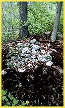
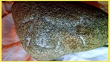
with a metal detector on land in Minnesota I came across a group of rock
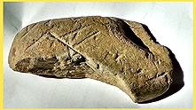
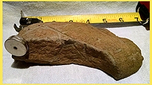
cairns in which I had found a rock that had been fashioned in shape, but also
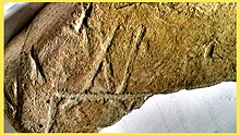
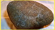
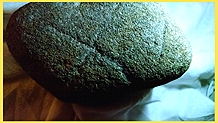
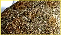
had what appeared to be "inscribed " characters. The rock was found
inside a 4x9 rock pile with heavy lichen growing on the top. The markings are
on one side only and strokes are short and deliberate, the depth of the
scribing is uniform therefore eliminating the possibility of plow scars. The
land that it was found on is a series of narrow ridges overlooking a vast
wetland (maybe a lake in an earlier period).
Assuming these rock piles are burials, The local Ojibwa never
practiced this method of rock burials, but according to research the
"Ogam" culture had practiced this custom. The "cairns"
and the "wall building" (Celtic) do reflect early European
practices. Based on my research the only text that matches the characters on
the rock are "OGAM", "RUNE or "ROMAN". After contacting Hugo
Kennes of Belgium, he verified that the lines are clearly linear scripts,
decoded as Ogam Script [Also see: Online OGAM].
Ogam is like our alphabet: a set of symbols that can be used for several
languages worldwide. Gérald Boutet's
complete site translation and interpretation includes a description of
American Ogams, the Medawiwin Society and the Algonquin-type language of the
ogam script.
This site in central Minnesota is made up of a mixture
of wetlands and ridges. The sand and
gravel soil, with its accompanying low P.H provide host to “hardwoods” such
as red and white oak as well as other faster growing building staples such as
Poplar and Pine. Most Ground cover
consists of elder/ briar. The area was first
logged in the late 1800’s.….Historic Artifacts uncovered offer
time stamps in history, such as the spent rifle cartridges that were flagged
by my metal detector, sitting slid between the rocks near the surface of one
of the moss covered rock piles.
“U.S.C CO” United States Cartridge
Company, founded in 1868 closed 1902. One could not help but
wonder if the “Rock pile” was used for a defensive cover, as clearly two
shots were fired. My guess is, that was
not the only surprise confrontation experienced in that area throughout
history, because it seems that this same trail was portaged by early European
explorers travelling to and from Lake
Superior and other ancient waterways such as the Mississippi River or the Red River Valley. Indeed, it is in the area where ancient
Norsemen may have travelled (See Norse
Exploration). Another Find that
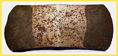
divulged a date came in the form of an Historic “saddle axe” that was found with
a metal detector by fellow researcher “TINA HERZOG” at the base of an very
large oak tree, next to a wall of rocks, that seem to go on into the
woods. This double bladed axe head
had a manufacturer stamp from the “Rixford”
Axe Co." (The stamping was a branding practice utilized in
approximately 1874, after initiation of axe production). "Saddle
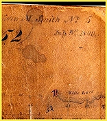
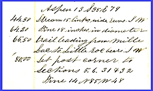
Axe” found with a metal detector While exploring around the area of
a trail referenced in the field notes of the original surveyor of Morrison County
(1842). it is here that I noticed a strange phenomenon involving the
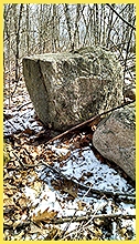
placement of rocks and boulders (some over 300 pounds). There are moss
covered rock piles “cairns,” and other deliberately placed large rocks
forming a “low wall” that connect and incorporate mammoth boulders. Even though it is a nationwide anomaly,
the purpose or culture responsible for this type of work is speculation at
best. Taking into account the
discovery of the “Ogam” inscribed stone, my research pointed me to “Viking”
exploration or possible Phoenician mining, but also these cultures seem to
match the context of the evidence provided by site analysis, and still
provide a bridge to early European contact.
The early Mandan nation often referred to as the “Welsh Indians”. Written in a letter on January 22, 1804 to
Merriweather Lewis from the President Thomas Jefferson; Jefferson specifically requests that the
expedition make contact with, and verify the existence of a white, blue eyed
tribe of natives referred to as the “Welsh Indians” later known as the
“Mandan Nation”. Their Language was
derived from European influence, as well as their form of written
expression. 1842
Field survey notebook The rocks and Boulders themselves have
been lying untouched for quite a while based on the lichen (moss) growing on
the rocks. Wikipedia remarks indicate that “lichen” grows 1-2
millimeters in diameter per year.
There are boulders within this area that have “lichen” growth with
diameters 20 – 30 inches, about 635 years, which translates to roughly in the
1400s. The “Kensington Runestone” has an inscribed
date of 1362 AD. G.P.S overlay of the area in which inscriptions have been
located.
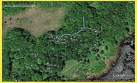
The above picture on the right is a G.P.S overlay of the
area. “Cairns” marked
as sites, and the blue line represents the “boulder wall”. The trail referenced in the surveyor notes
is evident through the clearing and into the woods. The objects, rock piles, walls, and large stones are very
interesting. A number of thoughts
come to mind. The wall seems to be
the most permanent feature of the site.
If it could be established that the wall was ancient, perhaps by
recovering at some point samples of detritus that were not buried deeply, the
wall structure might be aged by carbon dating of the associated plant
material. Who does this type of
work? Some questions: What purposes might the wall have served? Are the stones the end result of glacial
till? Was the wall used for
defensive purposes, for animal confinement?
Might the wall have been originally constructed taller and arranged by
hunters so as to herd animals to a kill point? The “beginning” or the “end” of this “wall” leads to a common
area on top of the ridge, where food preparation and social interaction took
place. There are circular rock lined
holes, (fire pits), and a flat surface area carved out of a boulder
specifically placed upon smaller boulders to prevent from settling and keep
consistently level. Boulder
top modified as a sturdy and level work platform
Whatever the purpose, there is a “synergy” built into
the placement of these boulders. Some
boulders are barely visible, as freeze /thaw cycles over time lower them into
the soil. These types of phenomena
(strange rock piles in the woods) have been documented all across the middle
United States, with no tangible artifacts recovered. However most “cairns” that have been
studied did contain burnt wood, at or about a 36” depth. With the aid of a metal detector I found
a few interesting pieces. This
piece “flagged” by the metal detector as Iron /Nickel Also
“flagged” by metal detector The “incising” shows… a uniform depth and width
of the tool used to create the text.
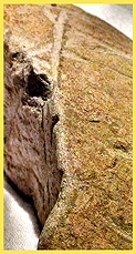
The piece was clearly fashioned in shape using a downward “chisel” cut
in at least three evident areas to define this shape. The characters were transposed with the
same instrument. After researching
various ancient texts, I had found that in the “Futark” alphabet the
inscription closely resembles an “Ansus”.
Although there are close similarities to “Roman” Numerals (
Phoenicians had adopted these numerals for there accounting system) and there
is also a strong resemblance to “Ogam”.
It’s worth mentioning that the ancient culture had buried their dead
deep in holes vertically, and covered
with rocks. The “X” with the little
hook on it has actually surfaced in archeology research conducted by Scott Wolter (Author of the book “The Hooked X) Mr Wolter Wsa contracted by the town of Kensington to authenticate
the ancient text of the famous “Kensington
Runestone”. This text
tells a story of 8 Geats and 22 Norweigans returning from a hunting
expedition only to find “ten men red with blood. A grisly warning to all who dare to venture. This story has been inscribed in stone,
utilizing the futark alphabet in the year 1362 AD . The town of Kensington lies about 100 miles south west of this
site. Texts
Resembling Roman Numerals? “A Picture
is worth a thousand words”… The following were found with the metal detector in the
same area: = = = = = = = = = = = = = = = = = = = = = = = = = = = = = =
= = = = = = = = = = = = = = = =
= = = = = = = = = Acholonu, C. O. 2005. The Gram Code of the African Adam. CARC Publ. (PMB 5197, Nigeria, Abuja); ISBN 9783199714 Acholonu,
C. O. 2009. They Lived Before
Adam: Prehistoric Origins of the Igbo The Never-Been-Ruled.
CARC Publ. (PMB 5197, Nigeria, Abuja); ISBN 9783199714 Acholonu,
C. O. 2010. The
Lost Testament of the Ancestors of Adam:
Unearthing Heliopolis/Igbo Ukwu - The Celestial Cities of the Gods of Egypt and India). CARC Publ. Boutet, Michel-
Gérald. 1996. "The Celtic Connection." 1996,
"Midwestern Epigraphic Journal, Vol 14, 2000." Fell, Barry.
1977. America B.C. New York: Quadrangle / The New York Times Book Co., . Fell, Barry. 1974.
An Introduction to Polynesian
Epigraphy with Special Report on the Moanalla Stele known as Pohaku ka luahine.
Polynesian Epigraphic Soc, 1974. Fell, Barry. 1974.
Life, Space and Time: A course in
Environmental Biology.
Harper & Row, NY. 417 p. Fell, Barry America BC, Fell, Barry. 1976-77.
America BC. Ancient Settlers in the New World. Pocket Books, NY. 312 p. Fell, Barry. 1977. America
B.C. New York: Quadrangle / The New York Times Book
Co. Fell,
Barry. 1982. Bronze
Age America. Little, Brown
and Co., Boston, Toronto. 304 p. Fell, Barry. 1983.
Saga America. A Startling New Theory on the Old World
Settlement of America before Columbus. Times Book, NY. 392 p. Fell, Barry. 1985.
Ancient Punctuation and the Los Lunas text. The Epigraphic Society.
p. 35-43. Fell, Barry. 1989.
America BC: Ancient Settlers in the New World. Pocket Books, NY. (revised ed.) Paine, Myron. 2007.
Frozen Trail to Merica: Talerman,
Galde Press, Lakeville, MN. Paine, Myron. 2008.
Frozen Trail to Merica: Walking to Merica, Galde Press,
Lakeville, MN. |
í
