File: <mystery.htm> [Educational
material: Quote cited references] Bibliography <Archeology> <Index>
|
AMERICA’S STONEHENGE (MYSTERY HILL, SALEM, NEW HAMPSHIRE) www.stonehengeusa.com & (Contacts) This archeological site was originally opened to
the public in 1958 as “Mystery Hill Caves.”
The name became “America’s Stonehenge” in 1982 as acquired data
indicated its relationship to the Stonehenge in England (see Photos).
Various names have been given to the many structures found at the
site. William B. Goodwin who was the first
researcher to purchase the site in 1937 labeled some, like the Sacrificial
Table. Frank Glynn named many while
he was president of the Connecticut Archeological Society in the 1950’s as he
was correlating the site with Bronze Age cultures of Europe.
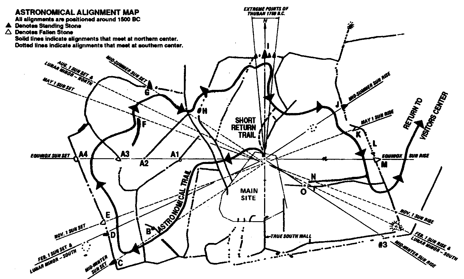
The site is thought to have been constructed principally to predict
astronomical events and is under continuous research and study. Such events were of considerable importance
to the maritime culture that is thought to have predominated in the
area. The public generally accesses
only 20 acres of the total 110 acres.
Continuous efforts are made to date various excavations using the
radio-carbon method. Estimates have
produced dates as early as 2,000 B.C.
with all alignments having been fixed around 1,500 B.C. The alignments that have been identified
are as follows (see MAP):
A. Equinox Alignment.-- This
alignment is accurate for both Spring and Fall Equinox sunsets.
B. Moon Standstill Alignment.--
As viewed from a large boulder about 20 ft. north of the south end of this
wall, the Winter Solstice Stone becomes the most southerly position of the
18.61 year cycle of the moon. At the
end of each cycle due to its seeming nonmovement this phenomenon is referred
to as the Standstill of the Moon. The
Winter sunset alignment also passes across the southernmost end of this wall.
C. Winter Solstice Sunset
Monolith.-- This was the firs monolith suspected to be a solar
alignment. Robert E. Stone
photographed it at sunset on 21 December, 1970. The principal stone marked the southern most set of the sun at
about 2,000 B.C., but today has changed because of changes in the earth’s
tilt.
D. February 1st
Sunset Alignment.-- This standing stone is aligned to the setting sun on the
first of February. It also lines up
with the northern edge of a stone circle 25 ft. to the west, off the trail
system. It has been determined to be
a lunar minor alignment. Another
lunar alignment passes through the center of the “Watch House.”
E. November 1st Stone.-- This
stone is aligned with the November 1st sunset, a date that has
considerable importance in many ancient calendars.
F. Large Curved Wall.-- This wall
that is aligned to true north is similar to post colonial walls that were
used as rock dumps, but additional research is required. The May 1st sunset alignment
crosses the northernmost end of the wall.
G. Summer Solstice Sunset
Monolith.-- This is similar to the Winter Solstice Monolith but lines up with
the summer solstice sunset, the most northerly setting of the sun about 2,000
B.C. at the Salem, New Hampshire latitude.
H. Eye Stone.-- The stone is
badly weathered but contains an unknown carving. It appears to be another lunar alignment for the 18.61 year
cycle of the moon as viewed from the observational center.
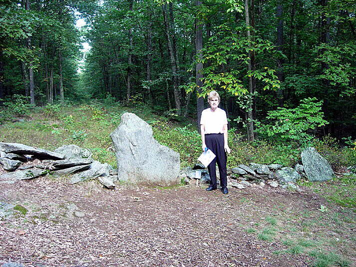
I. True North Stone.-- This stone
(Photo) aligns with the true north for the pole
star. Excavations around the base of
the stone uncovered a fire pit located at a higher level than its base. This indicates that the stone has been in
place prior to the fire pit. A
radio-carbon dating of charcoal samples give a date of 650 A.D.
J. Summer Solstice Sunrise
Stone.-- This stone was aligned with a stone circle located ca. halfway
between it and the viewing platform around 1,500 B.C. At that date the sun rose at the top of
the notch in the far northeast horizon.
By 2004 the sun rises at the bottom of that notch. The difference is due to the changing tilt
of the earth and this provides another means for determining the age of the
site.
K. May Day Monolith.-- May day
is an important day that has been celebrated since ancient times. This fallen stone is the largest monolith
to be discovered at the site. It
aligns with May 1st to the
present day.
L. Multi-Stonding Stone Wall.--
The wall is still mostly in its original condition. A number of standing stones are slightly leaning and resemble
the teeth of a shark.
M. Equinox Sunrise Stone.-- At
the spring and autumn equinox the sun rises over this fallen monolith.
N. November 1st
Sunrise.-- There is a fallen stone here that is aligned with the November 1st
sunrise. There is a “V-shaped” notch
at the edge of what was the top of the stone. In this way it is similar to the Bert Stone, one of the two
stones aligned with the Winter Solstice Monolith.
O. Bert Stone.-- From this stone
with its notch on top it is thought one would observe the winter solstice
sunrise. |
|
|